Analysis of Roger’s Sinai adventure
This page contains further information about, including my photographic and geolocational analysis of, Roger’s adventure in which he got lost — and found — in the Sinai desert; please see the first page for Roger’s original story in his own words.
This page was published on 2022 August 23, and last modified on 2025 January 6
⏱ A 16-minute read
The tale of such an adventure immediately poses at least as many questions as it answers: how did he get so lost? Where did he end up? How far did he actually walk? By what route did he return with his rescuers? How accurate was his recollection and his sketch-map? Can we see the area on an aerial photo?
Of course, such a puzzle is irresistible to me!
My main visual clue initially was Roger’s photo (reproduced above) taken from at/near the lunch-spot after his rescue was completed. To try and obtain a match to the view, Google Earth was my tool of choice.
Roger’s account says that they had spent that morning reaching and visiting Serabit el-Khadim. Fortunately that location is well defined, and allows us to concentrate our search straight away in the vicinity of 29°02’ North, 33°27’ East. To the north and east, less than a mile’s journey would bring a traveller to comparatively wide-open expanses of sandy desert, whereas Roger’s photo shows (and indeed his account depicts) nothing of the sort.
The account describes how from [Hathor’s monument] we went on a
short walk
(my emphasis) to the lunch spot. In this sort of
terrain, it seems reasonable to suppose that a short gentle
midday walk in desert conditions and hilly terrain could be presumed to
be no greater than of the order of a mile; and we would need to be
searching in an area away from the north or east from Serabit
el-Khadim because those directions are unhelpful as I have described.
So, Roger’s circulated photo taken later in the afternoon after his rescue shows the view with shadows being cast by the sun off to the right and somewhat behind; in the northern hemisphere at 16:30ish, the sun would have been in the south-west, so this tends to suggest that he was pointing his camera towards the east and perhaps somewhat north.
But it was quite hopeless! I could see, immediately and profoundly, how Roger came to be lost. Everywhere looks like everywhere else. Even with Roger’s sketch-map (and bearing in mind the possibility that it were seriously inaccurate), I could not fathom the location. Based solely on his photo which he circulated together with his sketch-map and his essay, I think there would have been no hope of finding the location. Indeed, I dimly recall that I tried doing so a few years ago — but, in spite of the attractiveness to me of such puzzles, and the keen interest which I felt sure my dad would have taken in any success that I might have been able to achieve, I had to abandon the task and regard it as impossible.
In May 2005 I did also talk to Roger about GPS receivers, which were around that time starting to become commercially available for non-ridiculous quantities of money; indeed, my brother had borrowed & carried mine in February/March of the same year when he and Roger climbed Mount Kilimanjaro. I told Roger:
You wouldn’t have had this story to tell if you
had a GPS receiver similar to mine. Even if it were just switched on and
carried in your pocket, it would be producing a ‘breadcrumb trail’ to
which you could refer when you realised you were getting lost -- allowing
you (a) to see whether you’d been going round in circles, and (b) to
retrace steps that you could see you’d taken. If you’d told the unit to
make a note of where you stopped for lunch (the return target) it could
have guided you back to it. But it’s typical of me to suggest
this!
On 4 August 2022, on one of my many house-clearing visits to Roger’s house in Cambridge, I encountered a letter on the doormat hand-delivered by Roger’s friend The Reverend Dr Andrew Macintosh (RIP), former Dean of St. John’s College.
Context: Andrew and Roger overlapped as undergraduates at St. John’s, and were for many years both present at meetings of the School Governors. I recently discovered that Andrew officiated at my christening when I was 3 months old. Aged six I stayed with his family when my parents were abroad; Andrew and I were both present together on several choir tours and countless chapel services. He knew Roger for most of his adult life, visited him on his doorstep repeatedly during Covid times and his final weeks, conducted his funeral in 2021 (which I think must have required an exceptional amount of fortitude), and wrote Roger’s obituary for the College magazine, Eagle (see page 96).
Andrew was, for some twenty years, a guest speaker on Wind Sand & Stars expeditions, and he took part in the 2005 Sinai expedition in question.
And now in 2022 he posted through the door for us Roger’s sons a printout of his friend’s tale (he would not know that I already had all of Roger’s computer-files) to ensure it was not forgotten. This prompted me to prioritise the story’s preservation on this website for posterity.
Andrew duly received my email thanking him for the printout, in which I told him I thought I’d solved the puzzle — he replied,
Hurray! I was lost and now I am found…A
As well as all the foregoing, including the PS note in the sidebar, Andrew so tenderly counselled me by email when I was grieving.
Andrew died in December 2024.
Spurred on by Andrew Macintosh’s prompting, as I sought to publish Roger’s tale of adventure I re-read it hungrily; and equally predictably I just had to have another look for the location using Google Earth.
And something else tickled my imagination: when Roger realised how badly lost he was, and after he had ascended to a summit, before he lay down to shelter and pray for rescue, what did he do?
He took a picture of himself.
I wonder…
I wonder whether I could find that photo? Quite apart from the puzzle, it would be intriguing to see a photo of himself which Roger took under such conditions — not knowing whether it would be found before his body was.
Roger did not have a digital camera, so I would ordinarily be looking for a physical photograph. Even by this point in our mammoth efforts to tidy up, I did at least nominally own all of Roger’s photographs, but finding any given one — particularly from a colour-print film and particularly from more recent years — would itself be a very troublesome task and with no guarantee of success. But what about those photo-CDs? Some films from the 2000s and 2010s, when they came back from processing at Jessops, were accompanied by a CD-ROM containing moderate-resolution (and, to be honest, only moderate-quality) scans of the photos. Confusingly the image-files were also often, though I think not always, numbered in reverse order.
Given that one of Roger’s photos from this episode was already distributed electronically — and Roger owned nothing so fancy as a scanner — perhaps the other 2005 Sinai photos were on one of those CDs too?
![Roger Griffin’s “lost” selfie.
This is a link to a larger version. [PHOTO: Roger Griffin “lost” selfie: 66kB]](rfg-lost-selfie_MD.jpg)
Above: Here it is! This is the photograph which Roger grimly took in the forlorn hope that it might help tell the story of his demise if that was the outcome of his misadventure.
To my amusement and satisfaction, exactly such a photo proved to exist, as you may see above. It shows Roger dressed just as he described, and carrying nothing except a wristwatch and a camera.
The object in his hand would prove, I think, to be the opening half of the leather case for his Nikon FG camera when used with his moderate-range manual-focus zoom lens. He has taken care to set up this photo on quite a telephoto setting, which offers us less sense of breadth and depth than the originally circulated one; but both he and the distant mountain are in focus, as no doubt he intended by use of a small aperture and a comparatively long exposure (easy under such bright conditions). Equally typically, he set up the photo so that he was facing directly towards the sun, hence the camera will be facing to the north-east. He has the sort of grim expression that you might expect from someone facing the set of unknowns which Roger was indeed facing at that moment.
But in furthering the story, this doesn’t seem to help very much, really, does it? It mostly serves to illustrate the sort of ‘badlands’ terrain in which every part looks essentially the same as every other part, which was the cause of Roger’s predicament at this point.
Slightly crestfallen at the seeming loss of what I had imagined would be the ideal opportunity to fill in all the gaps and discover the unknowns from Roger’s tale, I looked at the other photos from either side of this point.
![The lunch-spot and its overhang.
This is a link to a larger version. [PHOTO: Lunch-spot and its overhang: 71kB]](lunchspot-overhang_MD.jpg)
Above: The previous image evidently shows the lunching place with its overhang of rock affording shade to the rest of the group.
If several of the chronologically previous images showed the remains of the ancient temple of Serabit el-Khadim, followed by a couple depicting details of lunch, then this must be the ‘lunch spot’, a near-semicircle of sandstone cliff at least part of which must face north (to have given shadow at lunchtime). The next photo after this would be the “lost” selfie.
The photo above was (in chronological terms) the next useful photo taken after the “lost” selfie (a mistaken intervening photo showing only slightly cloudy blue sky was quite likely taken whilst retrieving the camera from the selfie and accidentally triggering the self-timer a second time). It is clearly a deliberately taken photo, and shows imposing mountains surrounded by valleys, and more of the same ‘badlands’ terrain which is so difficult to gauge even by eye when physically there, let alone on a photograph. Was this a view of ‘pointed top’ from ‘flat top’? No, it looks to be on too large a scale for that: ‘pointed top’ was barely more than 20 minutes’ walk/scramble from the lunch spot, whereas this looks altogether larger.
The photo after this on the film is the one which Roger circulated, and which by his own description was taken just after his rescue was completed.
Therefore, the ‘mountains’ photo above must have been taken during the adventure, either from where he awaited rescue, or at some point during his rescue back to the lunch spot.
I now had enough information to complete the puzzle, although I didn’t know it.
I considered that it wouldn’t hurt to see if I could identify the location from where the ‘mountains’ photo was taken, as although it might not solve the puzzle, it would at least prove that Roger and his camera had been at that point during the height of this adventure, and thus ought to help me understand whereabouts the other locations could have been.
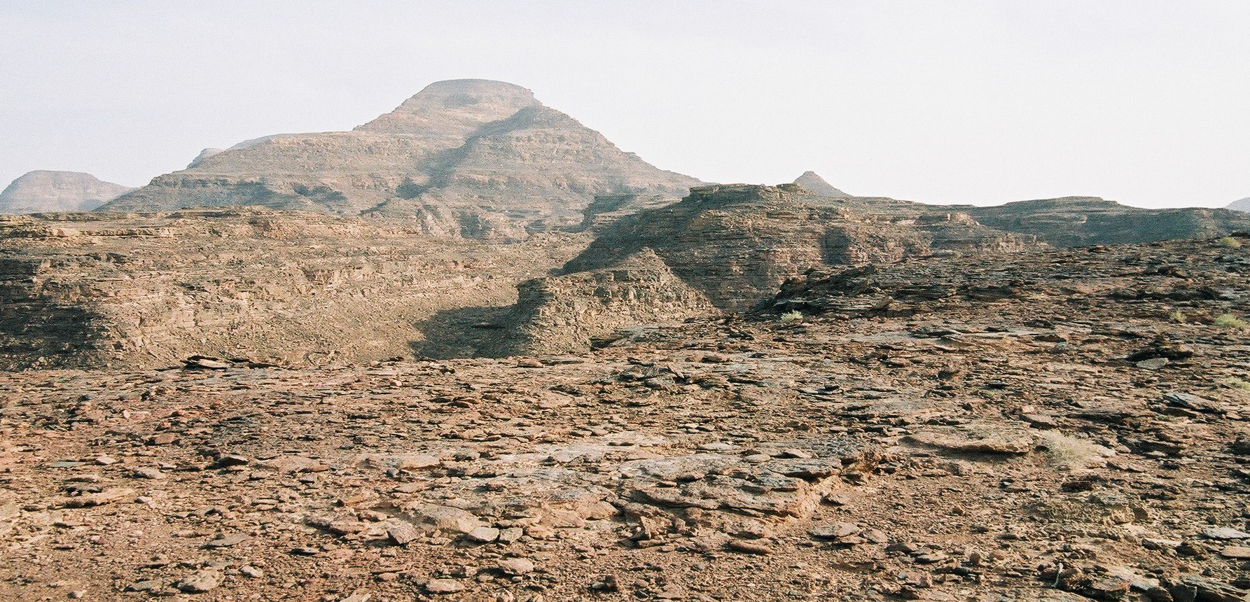
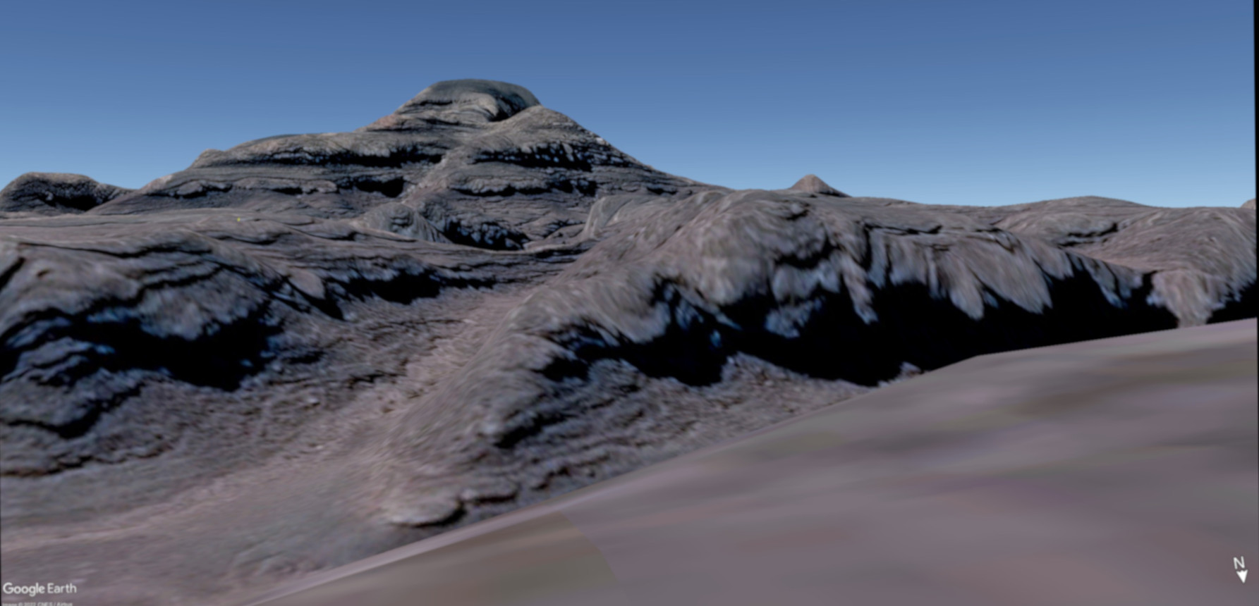
Bingo! We cross-fade here between co-cropped versions of my dad’s photo and a screenshot from Google Earth.
By not trying to solve the main puzzle, but by focusing only on solving the riddle of where this photo was taken, thanks to the highly distinctive mountains and particularly the little cone to the right and the knoll at far left, I was able to figure it out. The parallax between the primary mountain and the secondary one which is half in front of its right-hand flank was particularly helpful in establishing the correct position side-to-side as well as vertically. The exact topography of the little peninsula in the centre of the view is not quite so well represented in Google Earth, but I have a good match for everything else.
Thus, I succeeded in locating pretty precisely the place where Roger and his camera must have been at some point during the latter half of his adventure. The mountain in question is actually 1.13 miles away, due south, and fully 300 metres taller than the spot from which Roger viewed it.
Although I now had a good idea of the general area in which I should search, actually my breakthrough came from closer examination of both the originally circulated photo and the “lost” selfie: they actually have the same mountain in the background!
I think you will agree that there is a distinctive darkish marking down the lower part of the visible face of this mountain which is apparent in both, and which provides continuity between the two.
So, then it was a case of looking on Google Earth, starting by ‘standing’ at the location of the ‘mountains’ photo, and looking for a suitable candidate mountain in the distance. Sure enough there it was, complete with distinctive marking, 1.9 miles due east from there.
Even more helpfully, that mountain actually comprises a ridge with a dip along part of its length, and orientated in such a way that the dip changes from a dip (left photo) into a notch (right photo) as the position of the person viewing it moves north/south across the landscape. This allowed me to obtain an accurate radial upon which to search for the viewpoint in both cases.
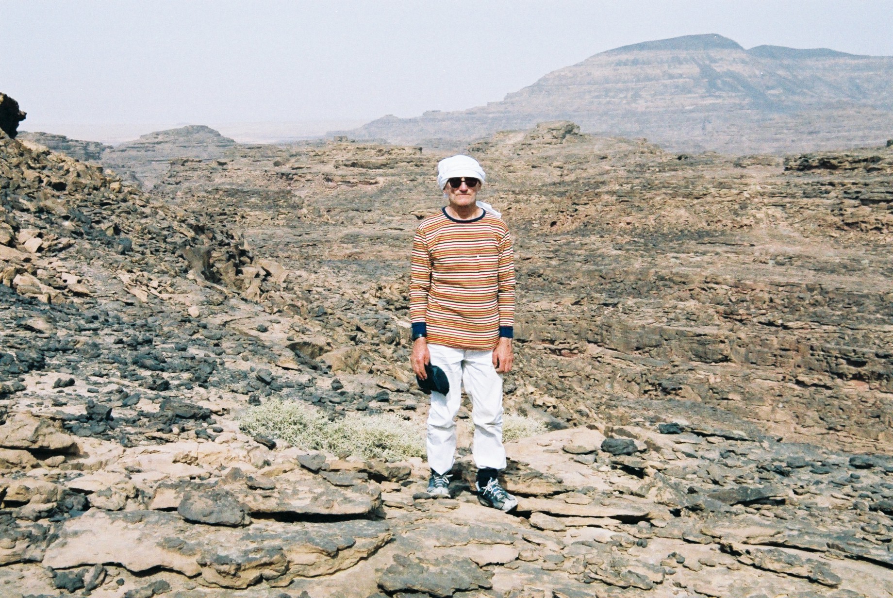
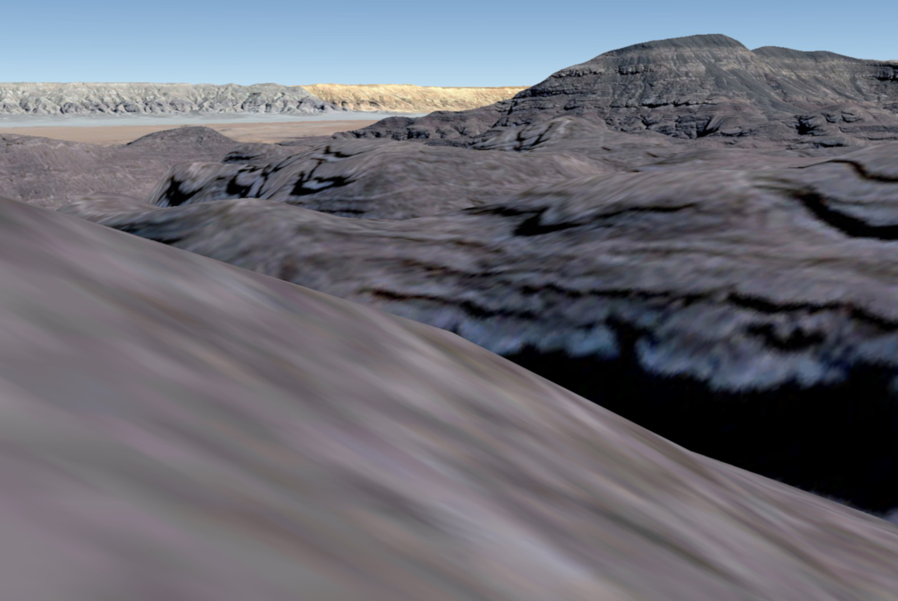
We cross-fade here between my dad’s “lost” selfie and a carefully cropped version of my screenshot from Google Earth. The distant mountains visible across the sandy desert in the GE view are some 12 miles away, and in reality were obscured by airborne sand and dust.
With some careful adjustment of position and a degree of trial & error, I found a location in which everything matched to my satisfaction — right down to the colouration details visible above and to the right of Roger’s head, and a lighter vertical ‘stripe’ apparent in the nearby landscape, coincidentally level with the notch in the skyline.
Again, the same characteristics of this type of terrain which make it so confusing actually proved very helpful in pinpointing this spot, because of multiple instances of parallax which I could use to line up the correct position (see, for instance, towards the left-hand end of the photo where a pronounced knoll on the horizon of Roger’s photo has the left-hand end of the adjacent mesa masking just over half of its length).
We now know where Roger was lost, and that his subsequent ‘mountains’ photo prior to the rescue being completed was taken on the opposite (northern) side of the nearby wadi, about 485 metres away.
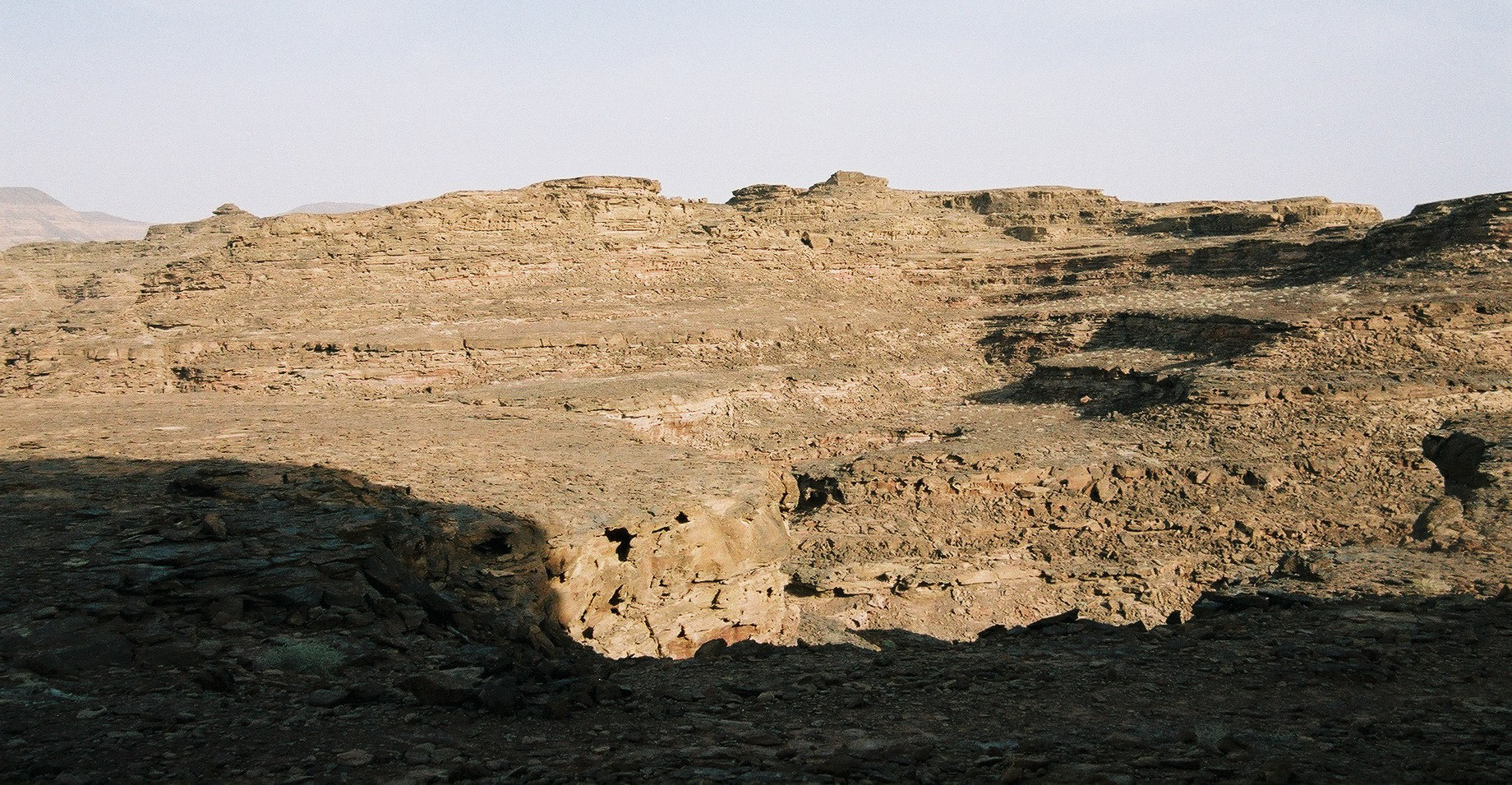
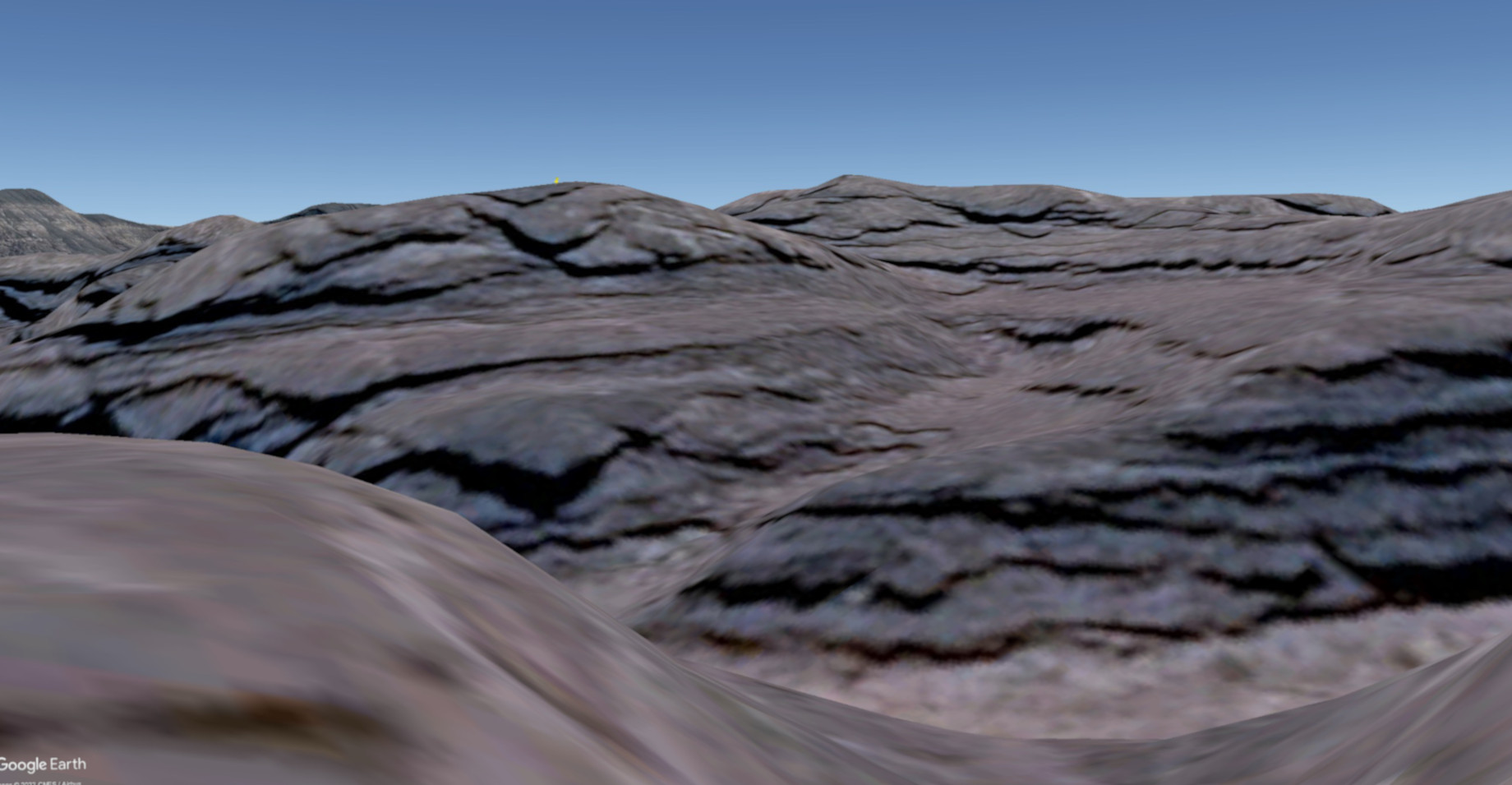
We cross-fade here between carefully cropped versions of my dad’s original photo illustrating the view which so mis-led him, and the nearest equivalent Google Earth image I could muster.
If we know where he ended up, and have a fair guess at the direction he had come from, and we know what the mountains in the background should look like, and we have a sketch-map even if its accuracy is potentially low… it ought to be possible to start selecting and checking some candidates for ‘Flat top’, ‘Pointed top’, and the lunching place itself.
It worked!
Accordingly, here is ‘Flat top’ (four-tenths of the way from the left-hand end of the image, complete with my yellow Google Earth placemark icon just visible upon its summit), and ‘Pointed top’ (just slightly beyond half-way across).
The fine detail in some of the nearby rock formations is not perfectly illustrated in Google Earth (which in any case is currently based, in this area, upon overhead-only imagery and so suffers most with horizontal views). Nevertheless there are enough features which are evidently the selfsame in both, to identify positively the location.
It is noticeable to me that it’s only after seeing this cross-faded version, while preparing this webpage, that I finally tumbled for myself to the problem which so bamboozled Roger (when he saw this view under much more adverse lighting conditions): there is that ‘declivity’ as Roger called it, forming a discontinuity in the rock between the hillock of ‘Flat top’ and that of ‘Pointed top’. There is a diagonal line at about ten o’clock / four o’clock which separates the two. With the computer-generated image, its location is made more apparent. Can you see it now?
The above oblique aerial view illustrates all features seen and related in the photos and words of this story:
lostselfie and awaited rescue;
![Plan view from Google Earth illustrating features of this story.
This is a link to a larger version. [PHOTO: Plan view of area: 53kB]](sinai-planview-web_MD.jpg)
Above: This plan view illustrates the relative positions from directly overhead. The ‘shelved’ nature of the landscape is particularly apparent.
My Google Earth placemarks for the locations described on these pages may be found in the .kmz file.
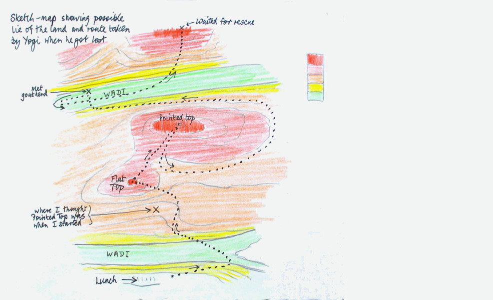
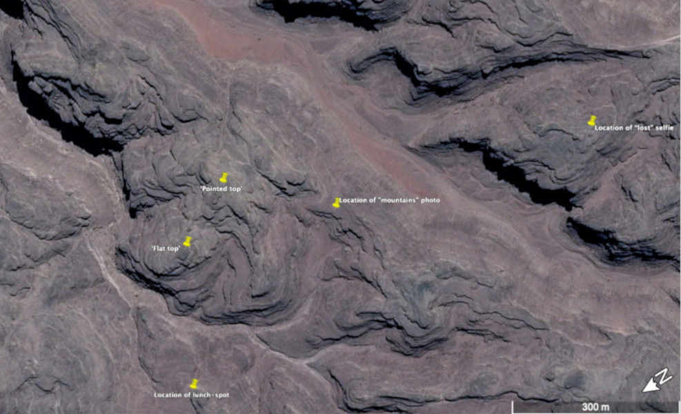
We cross-fade here between carefully cropped versions of my dad’s original sketch-map and the analogous plan-view from Google Earth. He did a lot better than he realised, and the salient features were all generally in the right respective locations!
Roger’s sketch-map has got the initial parts just as he thought: the lunch-spot shelving down to the right, the wadi splitting (actually it bifurcates twice!), and the relative positions and general shapes of ‘Flat top’ and ‘Pointed top’. The visible topography supports the notion of the error by which Roger ended up turning left too far and ending up in the wrong wadi.
That second wadi is indeed a lot wider: I can well imagine how he would have had misgivings about whether it was really the correct one, as he says! When we see it from the air, the fact that it is not quite parallel to the first one is apparent, but that is the sort of thing which would never have been detectable by someone making one visit — particularly if not with the specific intent of performing cartography.
From the data we now have, we know that Roger’s target of ‘Pointed top’ was a little under 400 metres away, and even by his likely walking-route it was only 515 metres. It should have been as simple and straightforward a walk as he had foreseen it to be!
Instead, having got there but been uneasy because the confusion had already begun, he then walked some nine-tenths of a mile further and got hopelessly lost in the process. It gives an idea of the difficulty of this terrain that, even when he had laid down to await any rescue that might or might not ever find him, he was actually only 880 metres (just over half a mile) from the lunch spot as the crow flies.
Upon rescue by the Bedouin, his return route to the lunch spot was probably about seven-tenths of a mile; and it is evident from his ‘mountains’ photograph that they, having crossed the wide wadi, climbed the mesa that forms the base of ‘Pointed top’ to reach a sort of ‘pass’ to its immediate west that formed the lowest crossing-point of that ridge.
Hence (although in his account Roger did not recall doing so) he must have persuaded his rescuers to pause long enough for him to look back the way they’d just come, so that he could take the photograph showing the mountains. Maybe it was in the course of doing so that the accidental photo of the sky got taken, actually?
I think I have just realised that Roger’s purpose in taking this photo was actually not so much to show the general scenery, but instead to show the hill upon which he waited for rescue (before even that information became confused or forgotten). We are looking clear across the large wadi (obscured by the edge of the mesa upon which they are standing), and the hill where Roger waited for rescue is a little to the right of centre, in the middle-distance just to the left of the small pronounced cone on the horizon.
As far as I know, Roger never returned to this area, nor did he ever satisfy himself as to where he had really ended up walking in the course of this adventure. I have a recollection sufficiently dim that I am unsure whether I am simply making it up, that I gave him some aerial views on my computer to investigate much nearer the time, so some 17 years ago at the time I write this. But I don’t believe he drew any useful conclusions, beyond the obvious one that this terrain is very difficult for someone who doesn’t know it well and is accustomed to it, as every part looks alike.
As a result of the process described on this page, I have during August 2022 completed the puzzle which he unwittingly set for me on Tuesday 12 April 2005.
Certainly I drew comfort from being able to share the solution to the puzzle with Andrew Macintosh, and emailed him to tell him so.
But it is a pity that I cannot share both my success and the answer to the puzzle with my father, as I know he would have been not only impressed and amused at what can be done from one’s desk, but interested to learn how nearly-right his sketch-map actually was. Maybe, in the act of solving his puzzle, I am drawing comfort from his life and his memory.
![Roger in his Yogi t-shirt in Sinai.
This is a link to a larger version. [PHOTO: Roger in Yogi t-shirt in Sinai: 48kB]](2005-04_RFG-films_72_MD.jpg)
Above: Roger 2 days earlier, by the chapel at the summit of the 2,285-metre Mount Sinai, and with his YOGI persona very much to the fore!